Bruce Stott is president and chief instructor of Gulf Islands Cruising School Ltd. in Sidney, BC. He’s sharing his know-how, to improve safe navigation for everyone.
If you are navigating a boat in coastal waters, then you need to be aware of tidal currents. I will discuss the definition and importance of knowing the currents, where to find current information, and using the current tables.
After reading this article, you should be able to read the current tables and navigate safely through passes. You should also be able to plan your voyage to take advantage of a favourable current.
Definitions
Current is the horizontal flow of the water. The current coming in from the sea is the flood current. The current going out to sea is the ebb current. When there is no flow, this time is slack water or the turn.
You will see many references to flood tide or ebb tide. These are incorrect terms and have confused many boaters.
Reference Station: a place where the times of slack water and maximum current as well as the maximum speeds of the current are tabulated in the tables.
Secondary Station: a place where the times of slack water and maximum current are tabulated as time differences relative to a reference station. Maximum speeds are given as either a percentage of the maximum speed at the reference station or as a maximum speed.
It is important to know the current as by proceeding with the current, you will decrease your travel time and save fuel. In the summer, with the light winds, one knot of current in your favour on a four knot boat speed is a reduction in travel time of 25 percent. With a fast powerboat, one knot of current added to a 25 knot cruise speed equals a four percent fuel savings.
Where To Find Information on Tidal Currents?
The current tables are located in the publication Tide and Current Tables.
How To Read the Tables
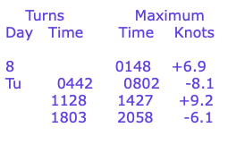
Following is a sample data taken from the Canadian Hydrographic Service, Tide and Current Tables, for Dodd Narrows.

To go through Dodd Narrows on the date above, you want to pass through during daylight at the time of the turn or slack. This would require you to be at the pass at either 1128 or 1803. If you are planning on travelling northward in the flood direction, 1128 would be the ideal time. You would have the current with you from 1128 until 1803. The times and speeds of maximum current are given in the right column. + refers to a flood current and – refers to an ebb current.
In this article I have outlined the definition of tidal currents, knowing where to find the information and how to read the tables. When navigating in coastal waters, tidal currents are an important aspect to know.
The biggest thing to understand is in most locations, the time of high water and the turn to ebb do not occur at the same time. Likewise, the time of low water and the turn to flood do not occur at the same time.
I have met many boaters who have attempted to use the Tide Table to determine the direction of the current. They have misunderstood that right after the low water, the current, in most cases, does not start to flood.
To find out the direction of the current flow, you must consult the Current Tables.
Safe boating,
Bruce Stott
Chief Instructor, Gulf Islands Cruising School Ltd
